Water in Istanbul: past, present, and future
Supplying Constantinople with Water: A Monumental Challenge and Solution
Introduction
Supplying Constantinople with water was a monumental challenge that required an equally monumental solution. The extraordinary remains of aqueducts, bridges, and cisterns reveal the ingenuity and expense committed to ensuring a steady water supply for the ancient metropolis. James Crow explores this remarkable engineering achievement.
The First Crusade and Impressions of Constantinople’s Water System
In 1097, the army of the First Crusade, weary from their journey across the Balkans, camped before the mighty walls of Constantinople. Enclosed within these fortifications was a thriving city adorned with richly decorated churches and grand monuments, home to an estimated 250,000 people—making it the largest city in Europe at the time.
ALSO READ: Etruscan Marvels in the Heart of Florence
What particularly impressed the Anglo-Norman chronicler William of Malmesbury, writing some 30 years later, was not just the city’s grandeur but its advanced water management system. He noted that sluices and drains cleaned the streets before emptying into the sea. Unlike medieval European cities such as Paris and London, which lacked such infrastructure, Byzantine Constantinople had inherited an urban water system from its 4th-century foundation by Constantine the Great.
The ‘Wonderful Works’ of Water Supply
Modern-day Istanbul, spanning both Europe and Asia, remains the largest city in Europe, with over 17 million inhabitants. For 1,700 years, it served as an imperial city for both the Byzantines and, later, the Ottomans. Unlike Rome, which had natural water sources nearby, Constantinople was surrounded by the sea on three sides, with only a minor stream and a single aqueduct from the time of Emperor Hadrian (117-138 AD) supplying its predecessor, Byzantium.
As the city expanded, a gravity-fed water supply system became essential. Two major construction campaigns in the 4th and 5th centuries led to the creation of the most extensive water system in the ancient world, stretching an impressive 267 km through the forested hills west of the city.

The Aqueduct of Valens: A Symbol of Imperial Munificence
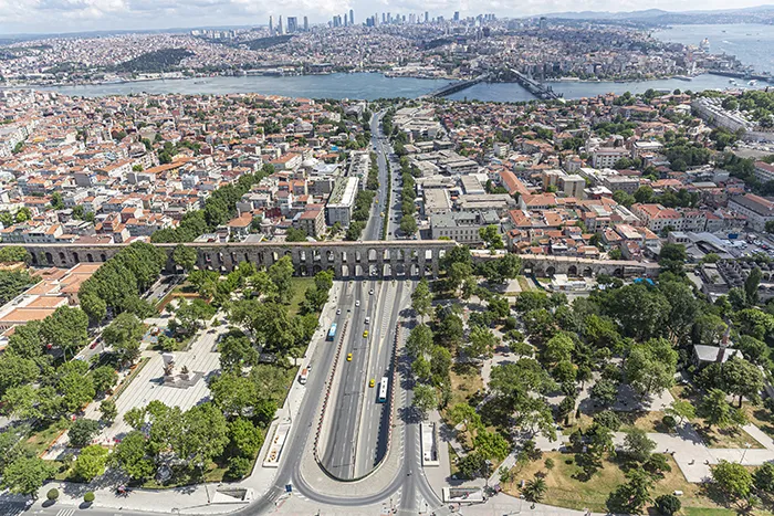
One of the most visible remnants of this system is the Bozdoğan Kemer, or Aqueduct of Valens, a 971-meter-long bridge straddling a major highway in Istanbul. Built in the 4th century, it transported water to the city’s ceremonial center, including the Great Palace, the Hippodrome, and Hagia Sophia. The aqueduct was restored multiple times by Ottoman sultans and functioned into the 20th century.
Beyond this structure, over 200 cisterns remain beneath the city’s streets, hidden relics of Byzantine Constantinople. Early studies of these cisterns date back to the 16th century, with the first comprehensive documentation published in 1893 by an Austrian archaeologist and a German civil engineer. The original Hadrianic aqueduct, sourced from the Forest of Belgrade northwest of the city, continued supplying water through restored Ottoman systems into the late 19th century.

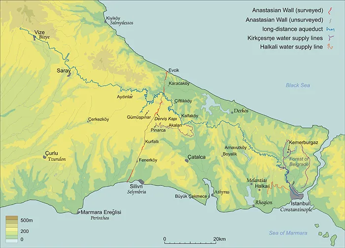
The Long-Distance Water System and the Anastasian Wall
For much of the 20th century, little was known about the long-distance aqueduct system extending into Eastern Thrace (Trakya). A significant feature of this region is the Anastasian Wall, built in the 6th century by Emperor Anastasius. This defensive structure, stretching 56 km from the Black Sea to the Sea of Marmara, was meant to protect the city from threats from the Danube and the Balkans.
Until 1990, the area surrounding the Long Walls and aqueducts was a restricted military zone, limiting archaeological exploration. However, with the fall of Communism, scholars gained access, and in 1994, James Crow secured a permit from the Turkish Ministry of Culture to document the remains. During this fieldwork, researchers discovered extensive aqueduct structures within the dense Thracian forest.

Mapping the Ancient Water System
At the same time, Prof. Kâzım Çeçen of Istanbul Technical University, an expert on Ottoman hydraulic engineering, turned his attention to the Thracian aqueduct system. His 1996 publication, The Longest Roman Water Supply Line, provided the first complete map of the channels and aqueducts extending beyond the modern town of Vize, aided by helicopter reconnaissance.
Few inscriptions survive on the aqueduct bridges. One notable example, now lost, was recorded near the Ballıgerme Bridge, a high single-span structure over a rocky gorge. Dating to the early 11th century, it commemorated the reconstruction of “the wonderful works” following damage from natural disasters and enemy attacks.
Fieldwork in the forests of Thrace, often guided by local villagers, was slow but rewarding. Investigators experienced a thrill akin to the discovery of Mesoamerican ruins when they uncovered massive stone bridges hidden in the landscape.
Evolving Research and Modern Technology
The research project evolved over time. Initially, scholars aimed to refine the map created by Prof. Çeçen and document the aqueduct structures within a historical framework, resulting in a monograph published in 2008. Subsequent collaboration with Istanbul Technical University focused on remote sensing and satellite imagery to enhance the study of the ancient water supply system.

As GPS technology improved, higher-resolution recordings became possible. Between 2014 and 2017, a new project titled Engineering the Water Supply of Byzantine Constantinople was launched in collaboration with civil engineers at the University of Edinburgh. Funded research supported two PhD students in analyzing the channels, topography, and water distribution within the city.
Conclusion
The study of Constantinople’s water supply system is a testament to Byzantine engineering prowess. While the city’s great palaces, churches, and fortifications often dominate historical narratives, its water infrastructure was just as crucial in sustaining a thriving metropolis for over a millennium. Today, these aqueducts, cisterns, and bridges serve as silent witnesses to the ingenuity of the engineers who shaped one of the greatest cities in history.